Website Moved to New Domain
Mamco Bank announces migration of
its official website to a new URL
mamco.bank.in
Redirecting you automatically in 15 seconds…
Mamco Bank announces migration of
its official website to a new URL
mamco.bank.in
Redirecting you automatically in 15 seconds…
Formerly known as Mahuligram, Malegaon is a city with a rich historical and religious background. It is located between 20.60° latitude and 76.60° longitude. Malegaon is a taluka in Nashik district, situated approximately 108 km northeast of Nashik city. The Manmad railway junction is about 35 km from Malegaon. Two rivers — Mokshaganga (also known as Mosam) and Giriparna (also known as Girna), both originating from the Sahyadri ranges and flowing eastward — touch the city. Girna flows to the south of the city while the Mosam River runs through the heart of the town. These rivers converge near the Zhazeshwar area in eastern Malegaon, and the merged river is then known as Girna.
Historically known as Mahuligram, the Malegaon region was under the rule of the Rashtrakuta dynasty around the year 1000 CE. Though prosperous and peaceful up to the 18th century, the region experienced periods of unrest. Before 1760 CE, Peshwa Nanasaheb granted the Jahagiri (feudal estate) of the Nimbayat region and surrounding villages to Nagoshankar Rajebahaddar of the Dani family from Saswad, Pune.
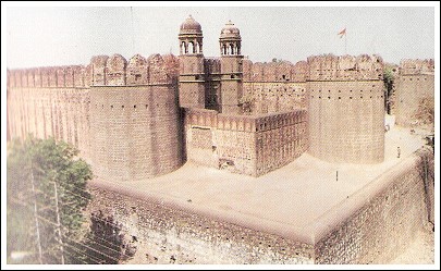
Initially, Nagoshankar served as a skilled commander in the army of the Badshah of Ahmedabad around 1755 CE. Impressed by his military accomplishments, the Badshah granted him several villages around Malegaon as an inam (gift). Between 1740 and 1765 CE, Nagoshankar constructed the historic Bhuikot Fort, which stands as a symbol of Malegaon's past glory. In 1818, the British captured the fort and took control. Many developments occurred in the region during the pre-independence period. The Malegaon Municipality was established in 1863 and later upgraded to a Municipal Corporation on 17 December 2001.
Malegaon is a densely populated town with an estimated population of around 500,000. The Muslim community forms the majority, followed by Hindus. Most residents belong to the middle class, and the city is renowned for its weaving industry, particularly the production of colorful sarees. Known for its thriving business activities, agriculture is also a major occupation in the taluka. Due to its prominence in powerloom-based weaving, Malegaon is often referred to as the "City of Powerlooms."
The city has around 25 banks and 10 credit societies, including 8 nationalized banks, 4 scheduled banks, 6 cooperative banks, and 6 branches of the district central bank. In the field of education, Malegaon is well developed, with a large number of government and private educational institutions.
Additionally, Malegaon is blessed with several religious and historical landmarks. Notable among them are: Khanderao Daulat of Chandanpuri, the Bhuikot Fort of Malegaon, the mountains and forts of Saller-Muller, the Renukadevi temple and tourist site in Chandwad (about 30 km away), the Girna Dam built on the Girna River, the Jain pilgrimage site in Mangi-Tungi, the Ravalgaon Sugar Farm and Ravalgaon Chocolate in Ravalgaon village, the Rokdoba temple just 5 km from the city, the ancient Mahadev Ghat and temple along Mokshaganga River, and the Mahadev and Ganpati temple with Maharashtra’s tallest 111-foot spire. The city also hosts religious sites for Muslims, Sikhs, and Christians.